The Cotswold Way is one of England's most rewarding long-distance walks - a UK National Trail that runs about 102 miles (164 km) along the Cotswold escarpment from Chipping Campden to Bath. Expect honey-coloured stone villages, big views over the Severn Vale, and a steady mix of farmland, beech woods, and history. You are never far from a pub or a bed, which means you can walk light and inn to inn. If you want the day-by-day version, we've also written a full 8-day guide for beginners.

The Cotswold Way in more detail
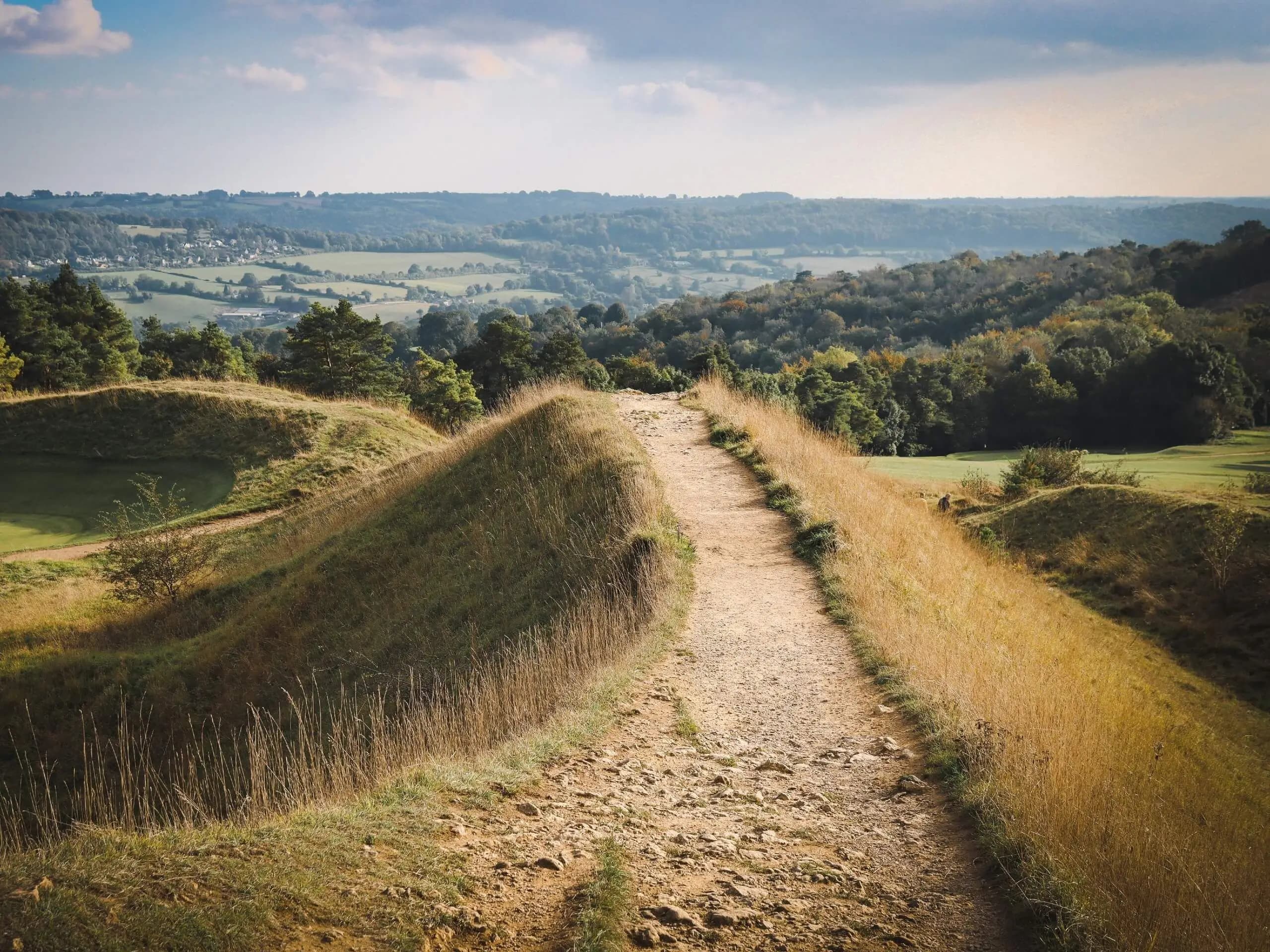
The Cotswold Way is a waymarked National Trail that follows the western edge of the Cotswold Hills. It runs roughly 102 miles (164 km) point to point, from Chipping Campden in the north to Bath in the south. It is not a mountain route - the high point is the Cotswold escarpment near Cleeve Hill - but it is far from flat. The trail repeatedly climbs onto the escarpment for the views, then drops back into valleys and villages, so the up and down adds up.
Total ascent over the full trail is around 4,500 m. The terrain is mostly good paths, farmland, and woodland tracks, with some quiet lanes. After rain it gets muddy, and there are plenty of short, steep pulls. So on paper it looks gentle. In practice it asks a bit more of you than the distance suggests.
Where does the trail start and finish?
The trail runs between Chipping Campden in the north and Bath in the south. Most hikers start in Chipping Campden, a pretty market town with a famous arched market hall, and finish at the trail's stone marker outside Bath Abbey. So in practice: start in Chipping Campden, finish in Bath.
Key towns and villages along the way include Broadway, Stanton, Winchcombe, Cleeve Hill, Birdlip, Painswick, King's Stanley, Dursley, Wotton-under-Edge, and Old Sodbury. These are where you'll find accommodation, food, and the occasional rest day. The standard direction is north to south, which also makes the finish (Bath) the easier place to catch a train home.


The trail is split into 15 official stages by the National Trail. Most people combine these into fuller days. Here's the route at a glance, broken into eight walking days:
- Chipping Campden - Stanton (16.5 km)
- Stanton - Cleeve Hill (22.1 km)
- Cleeve Hill - Birdlip (20.4 km)
- Birdlip - Painswick (11.7 km)
- Painswick - King's Stanley (14.5 km)
- King's Stanley - Wotton-under-Edge (19.6 km)
- Wotton-under-Edge - Tormarton (24.4 km)
- Tormarton - Bath (27.0 km)
How long does it take to hike?
Most people complete the Cotswold Way in 7-10 days, with about 16-27 km per day depending on how you split it. A comfortable plan is 8 days at roughly 19-20 km per day, though the final day into Bath is a long 27 km - don't assume every day feels the same. If you want shorter days, stretch it to 10 days and the daily distance drops to a relaxed 14-16 km. For the full day-by-day breakdown, see the beginner's guide. If you're new to long-distance walking, building in a rest day in Winchcombe or Painswick is a good idea.
Which direction should you hike?
The usual and recommended direction is north to south (Chipping Campden to Bath). The logistics are easier: Bath has fast train links to Bristol, London, and beyond, so finishing there makes getting home simple. Walking south also means you end in a proper city with plenty to celebrate with. There's no strong reason to walk south to north unless you have a specific constraint.
How to get to the trail
Getting to the start takes a little planning since Chipping Campden has no train station. The nearest stations are Moreton-in-Marsh and Honeybourne, both a short taxi ride away - carry some cash for the taxi just in case. From the south, Bath Spa is on the main line and well served by trains, so most hikers travel home from there. The trail is point to point, so you'll only deal with transport at each end. Given the good rail links, there's no need to rent a car.
Best time of year to hike
The best time to hike the Cotswold Way is spring (April-June) or early autumn (September-October). In spring the woods fill with bluebells and the fields are green; expect cool mornings around 6-12 °C warming to the high teens. Autumn brings golden beech woods and fewer walkers. Summer is fine too, with longer days, but it can get busy and warm, and rooms book up fast. Whatever the season, English weather is unpredictable - afternoon showers are common, so keep your rain gear handy.

How difficult is the hike?
On paper the hike looks moderate: no technical sections and modest daily distances. In practice it's a bit harder. The trail keeps climbing onto the escarpment and dropping off again, so the cumulative ascent and short steep pulls add up over a long day. Mud after rain makes some stretches slow going. The terrain is easy to moderate overall - not technical, but you'll want a solid baseline of fitness. If you regularly walk, run, or hike, you'll be fine. Building up your mileage in the weeks before, and breaking in your shoes properly, makes the whole thing more enjoyable. For more practical advice, read our 7 tips for hiking the Cotswold Way.


Can you hike it in sections?
Yes. The Cotswold Way is well suited to day hikes and shorter multi-day sections. The official stages make it easy to pick a stretch, and many villages along the route have bus or rail connections nearby. Rewarding shorter options include the escarpment around Cleeve Hill, the woods and viewpoints near Painswick, and the final approach into Bath. You can also walk a few consecutive stages over a long weekend and use local transport to get to and from the trail.
Is the trail easy to follow?
Yes. The Cotswold Way is very well marked with the National Trail acorn symbol on signposts and waymarks. Much of the route shares public footpaths, so keep an eye out for the acorn to stay on track. A backup is always smart - we'd suggest the free Cotswold Way app for offline navigation, daily distance, and elevation, so you can leave the paper map in your pack. Give it a try and let us know what you think. 🙏

Where to stay along the trail
The Cotswold Way is an inn-to-inn hike: you'll stay in inns, B&Bs, and small hotels in the villages each night rather than camping. That's part of the charm, but it does add to the cost - expect roughly £75-£125 per night, often with breakfast included. Accommodation in the smaller villages is limited and fills up fast, especially in summer, so book ahead in the planner. Staying as close to the trail as possible saves you extra walking at the end of the day - thank me later. For a tried-and-tested list of where to stay each night, see the full beginner's guide.
Food and drink options
Food access varies day to day, so plan a little. Many B&Bs and inns include breakfast, which sets you up for a big day. For lunch, grab something in a village café or shop when you pass one, and carry trail snacks for the stretches in between - several golf clubhouses on the route have public cafés where you can stop for a coffee. For dinner, the simplest setup is a pub or inn with its own kitchen so you don't have to walk far after a long day. A few things worth ordering:
- A proper Sunday roast or pie in a village pub
- Local cheese and bread for a packed lunch
- A pint of real ale to finish the day
Budget for meals separately from your accommodation. Card payment works almost everywhere, but it's worth carrying a little cash for taxis and the occasional roadside stall.
What gear to bring
Pack light - you don't need camping gear for an inn-to-inn walk. Focus on comfort and the weather. Good waterproof footwear matters since the trail gets muddy, and well-broken-in shoes prevent blisters over 100 miles. Bring layers, extra socks, and a reliable waterproof jacket; afternoon showers are common even in summer. In warmer months add sun protection and plenty of water. Trekking poles help on the steep, slippery climbs and descents. A daypack of 20-30 L is enough if you're using a luggage transfer service, or a slightly larger pack if you carry everything yourself.


Luggage transfer services
Luggage transfer is popular on the Cotswold Way for good reason - a service moves your main bag between accommodation each day, so you only carry a daypack. It turns the trail into a true comfort walk and is especially helpful if you're not used to carrying a full pack. The trade-off is that you'll need to book all your accommodation in advance and know your daily mileage. If you prefer a flexible, spontaneous approach, carrying your own pack is completely doable - just pack strategically.

Key takeaways
- Walk north to south, Chipping Campden to Bath, over 7-10 days
- Book accommodation in advance - villages are small and fill up fast
- Bring waterproof footwear and a rain jacket for the mud and showers
- Download the Cotswold Way app for offline navigation
- Read our 7 tips for hiking the Cotswold Way before you go